


All eyes are on the floating bridge, a phenomenon of engineering know-how, as light rail prepares to glide across the surface of Lake Washington.
Putting a train on the Interstate 90 bridge wasn’t easy to do, or done at a discount, and it didn’t come without delays or mistakes. But when the bridge opens to light rail passengers Saturday, with new stations in Seattle’s Central District and on Mercer Island, it will arguably be the most significant expansion in Sound Transit history.
With just two new stations, the regional system suddenly becomes just that, a system, spanning 58 miles.
That’s the big picture. The details of light rail’s impact, the meaningful changes to daily life and memory, are found in the neighborhoods where new stations open.
At Judkins Park Station in the Central District, with the Northwest African American Museum across the street and images of native son Jimi Hendrix decorating the station itself, light rail arrives to a neighborhood pummeled by the destructive highway-building and racist housing policies of the last century.
The scars remain: First, in families driven from their homes by plans for an I-90 interchange, and later by market forces that priced them out. And in the lay of the land, right where the station is, a tangle of ramps and wide roadways never meant for community life, let alone for people walking to catch a train.
After so much change and upheaval in Judkins Park, can light rail help heal the wounds left by government schemes? Maybe. But plans to make those roads less dangerous for pedestrians are far from realized, let alone funded. And many of the residents who suffered the blows are gone.
“When the Central District was majority Black, they were building the freeway right down the middle of it,” said Elmer Dixon, who co-founded the Seattle chapter of the Black Panther Party in 1968, and soon led a revolt against the city, county, state and federal officials who envisioned two highways — I-90 and one from the north called the R.H. Thomson Expressway — converging where Judkins Park Station sits today.
“Now with the new light rail, it’s actually benefiting the community,” Dixon said, adding that the stop should help bring more visitors to the museum.
As Dixon suggests, after decades of gentrification, many of the people who fought for a better neighborhood have left, priced out as the area grew wealthier, and whiter. The “ghetto” that highway planners described and sought to replace now has growing ranks of three-story condos with rooftop patios, and Teslas parked outside.
In the days when the highway divided the neighborhood, Black residents made up 73% of the Central District’s population, and just 16% were white. Now, the neighborhood is roughly 15% Black and 60% white. Judkins itself is 22% Black, 35% white and 19% of Asian descent.
Chukundi Salisbury leads the Black Legacy Homeowners project, which helps Black Seattleites buy and keep their homes for future generations. He grew up in the CD and played baseball at Judkins Playfield as a child.
“Homes were destroyed, and those homes didn’t come back for us,” said Salisbury. He points to Rainier Valley, where many Black families moved after getting edged out of the Central District, and how it’s home to the longest stretch of light rail trains that, dangerously, share the road with cars.
“Once again, we learned all the lessons on people of color, and then we went up north and applied those lessons and put it underground,” Salisbury said. “We just always seem to get the short end of the stick. It’d be good if we just acknowledge that. It’s great that we got this new light rail system. It’s going to help people get from A to B. But at the same time, we can acknowledge it’s not all just roses.”
Burned out with bulldozers
When Dixon moved to town in the 1950s, he was 7 and there was no I-90, no Highway 520 bridge, no Interstate 5. He remembers walking to Colman School just across the street from what is now Judkins Park Station.
“I walked by homes and houses,” said Dixon. “It was a neighborhood.”
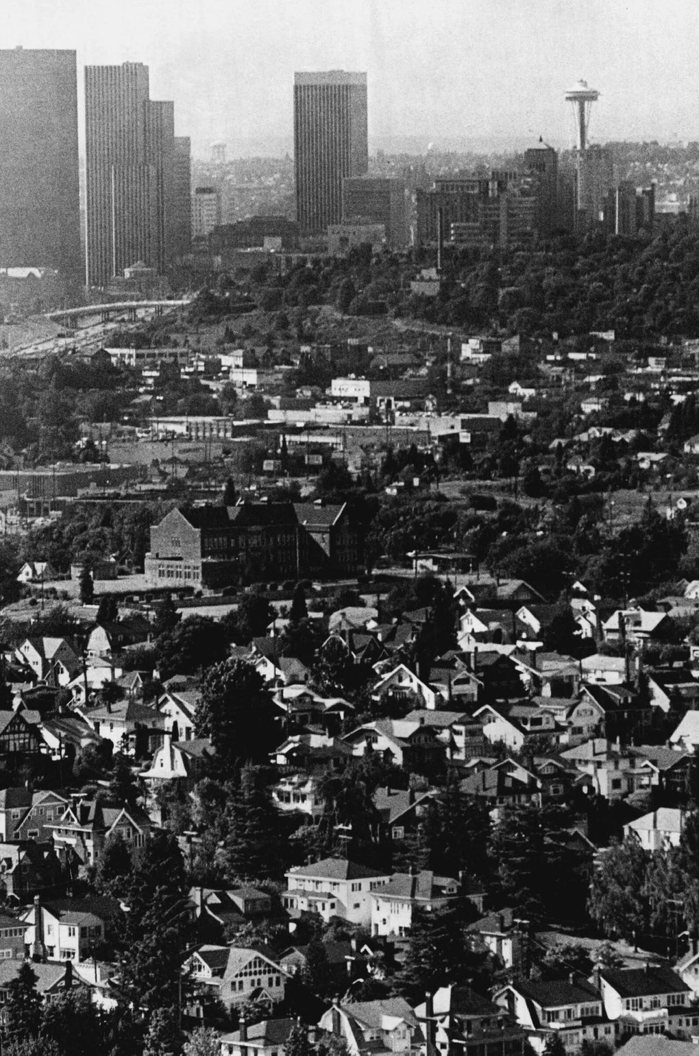
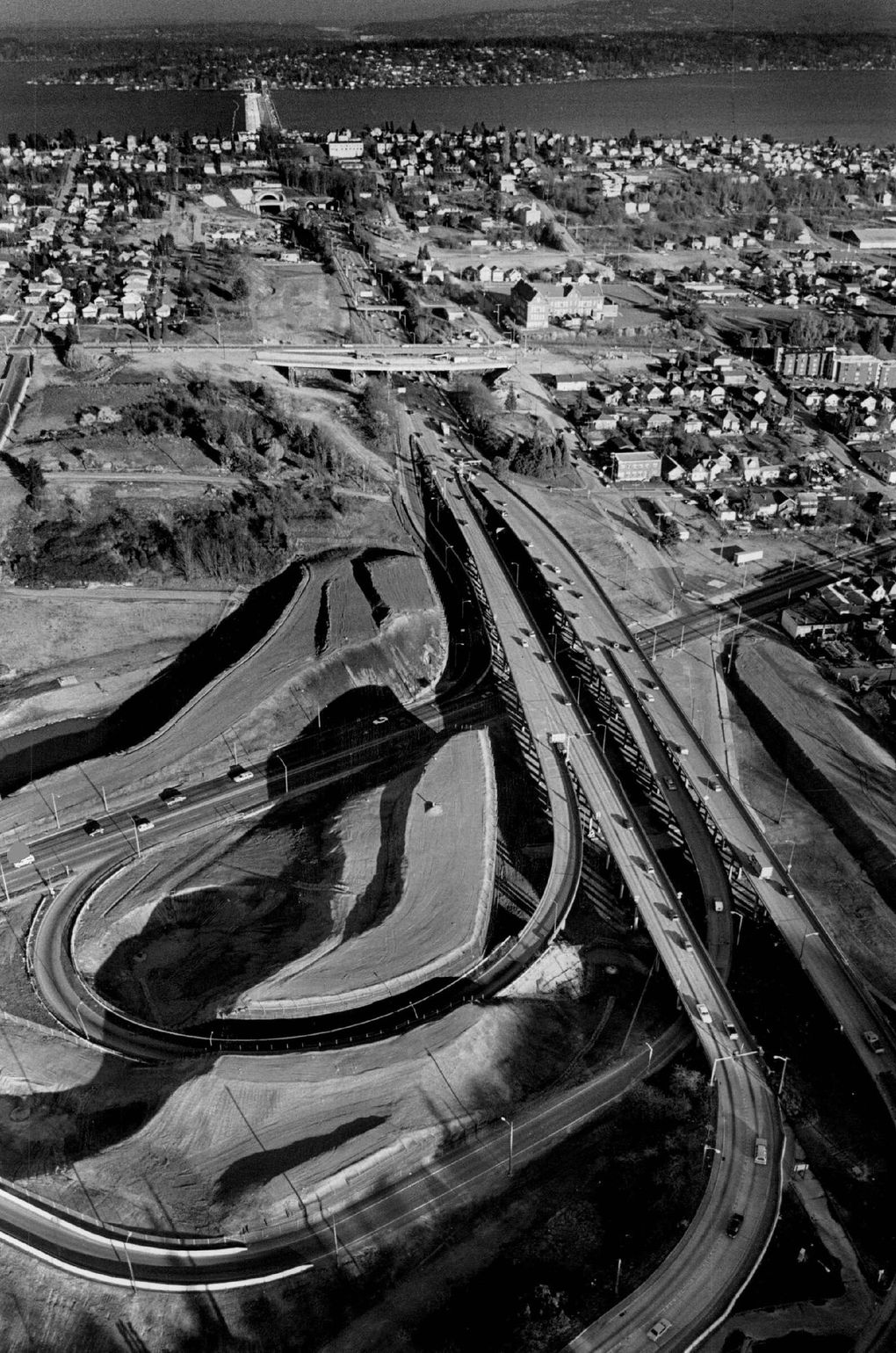
First photo, Sept. 3, 1978: The Colman School building, center left, has seen decades of change as I-90 carved through its neighborhood. Now it’s home to the Northwest African American Museum. (The Seattle Times archives) Second photo, March 4, 1986: A swirl of ramps for I-90 traffic takes shape near Rainier Avenue South, where neighborhood homes once stood. In the background are Lake Washington and Mercer Island. (Craig Fujii / The Seattle Times)
First photo, Sept. 3, 1978: The Colman School building, center left, has seen decades of change as I-90 carved through its neighborhood. Now… (Craig Fujii / The Seattle Times)
How Dixon’s family ended up in the Central District was no accident. His father got a job at Boeing and moved the family from Chicago. But as a Black family in the 1950s, they had little choice of where they could live, thanks to the American government. Redlining, as it was called, rated certain neighborhoods as “hazardous” for home loans, which segregated Black people and other communities of color. As a child, Dixon didn’t know this and had no idea of the change he was about to witness. But it began with the Yesler-Atlantic Urban Renewal Project in 1958, which zeroed in on Judkins with the intent to remove “blight.”
Per usual, this meant Black homes and businesses. Redlined districts. And like a surgeon’s scalpel, highway projects provided the tool, slicing with precision through Black neighborhoods across the U.S.
Work began on the massive interchange for I-90 and the Thomson Expressway, which was intended to head north largely along what today is Martin Luther King Jr. Way. In 1968, more than 200 homes were demolished, out of an estimated 4,000 houses that stood in the highways’ paths.
With homes coming down, residents rallied to prevent what had happened with I-5, when 40,000 people lost their homes. A coalition of middle-class white homeowners, retired people, environmentalists and activists, like Dixon’s Black Panthers, rang the alarm.
“It would’ve divided up the community, which had been happening in many parts of the country through Black communities, cutting them off and cutting them up,” Dixon said. “Of course, that was intentional, and we fought it.”
The resistance worked.
In January 1970, a standing-room-only crowd of 900 at a City Council meeting denounced a “white freeway through a black community,” according to a news story.
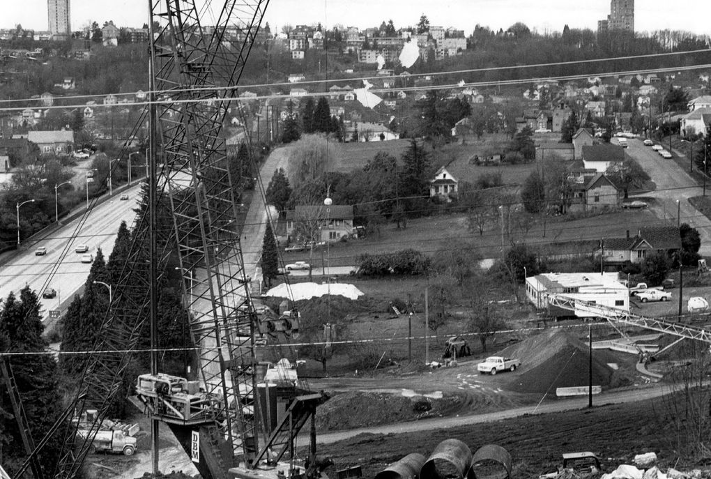
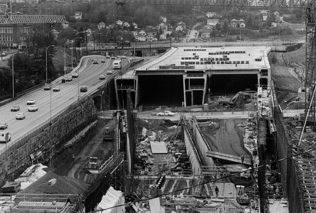
First photo, March 6, 1983: Homes and other buildings are being cleared from the path of the westbound lanes of the new Interstate 90. This view is west from Mount Baker Ridge. (Richard S. Heyza / The Seattle Times) Second photo, Jan. 15, 1988: Looking west, a long concrete lid takes shape to cover new I-90 lanes. (Vic Condiotty / The Seattle Times)
First photo, March 6, 1983: Homes and other buildings are being cleared from the path of the westbound lanes of the new Interstate 90. This… (Vic Condiotty / The Seattle Times)
The next day, a majority of council members voted against the I-90 plan, throwing it into limbo for years. The highway was completely redesigned as the state negotiated with the neighborhood to build a 2,000-foot lid over the freeway west of Mount Baker Ridge, as well as a new park and elementary school. Colman School, set for demolition, was saved and is now home to the Northwest African American Museum.
The opposition was even more effective with the proposed Thomson Expressway. In 1972, voters ended the project.
But the damage had been done.
The area “looked like Germany after World War II, or Watts,” said John Cannon, a neighborhood leader, in 1978, describing it as “burned out with bulldozers.”
Countless homes were destroyed, their lots left vacant for decades.
Around that time, Dixon moved his own family out of the neighborhood, but he saw something happening.
“That’s when white folks realized that the Central District is a prime area. They began to buy up properties people could no longer afford to upkeep. I watched that. I saw families I’d grown up around who lost their parents’ homes,” Dixon said. “That’s when everything shifted.”
Built for cars
Anna Zivarts, a visually impaired pedestrian and disability advocate, waits at a crosswalk with her son, Kaspars, who goes to school nearby.
The cars howl. It’s February, the sun is out, but the sky is dominated by the interstate highway flying above, and the incessant chunk-chunk of speeding cars up there, somewhere.
Finally, a walk signal. Zivarts, who wrote the book “When Driving is Not an Option,” and Kaspars begin the long march across wide Rainier Avenue South. They’re halfway across, and drivers coming off I-90 aren’t yielding. Mercifully, one finally lets them get to the sidewalk, where Zivarts pushes another walk button.
Only one more hair-raising crosswalk to surmount before she gets there: the westernmost entrance to Judkins Park Station.
Judkins Park really is a tale of two stations. It can be either the worst light rail station to reach, or the best. At the upper-level entrance, on 23rd Avenue South, passengers disembark just steps from two parks, a museum and a network of bike paths. Below, on Rainier, in the shadow of the flying freeway — the growling I-90 — pavement abounds and platoons of cars move by threateningly, or idle noisily.
But like exhaust, change is in the air. If the current thinking succeeds, this stretch of Rainier would be much calmer and make reaching light rail easier and safer. The ramps to and from the freeway will be reconfigured, with traffic lights and better crosswalks. Lanes will be taken out of Rainier, and more frequent bus service will arrive. Maybe even a protected bikeway will run along the former state highway.
Zivarts is part of a 23-member community advisory group that — along with traffic modeling and analysis — helped guide the state Department of Transportation last month to recommend closing one of the five ramps, from westbound I-90 to northbound Rainier.
“A lot of what we heard is, if we can only do one thing, it would be to remove this ramp,” said WSDOT’s April Delchamps, who helped lead the group through months of discussion.
Other agencies, like the Seattle Department of Transportation and the Federal Highway Administration, must still sign off on the recommendations, which include getting rid of the swooping ramps and replacing them with traffic signals, adding a pedestrian-only crossing on Rainier just north of the interstate, and reducing Rainier from six lanes to four below the highway.
There’s no money for construction, so years will pass before anything changes.
Making Judkins Park station easier to reach by foot, bicycle
Reaching a light rail station in the middle of an interstate isn’t the safest or easiest thing to do, as is the case with Judkins Park in Seattle’s Central District. City and state transportation workers have built new crosswalks, connected bikeways and installed better lighting. Drivers will notice: The state recently recommended closing a ramp from I-90 and eliminating two lanes on Rainier Avenue South.
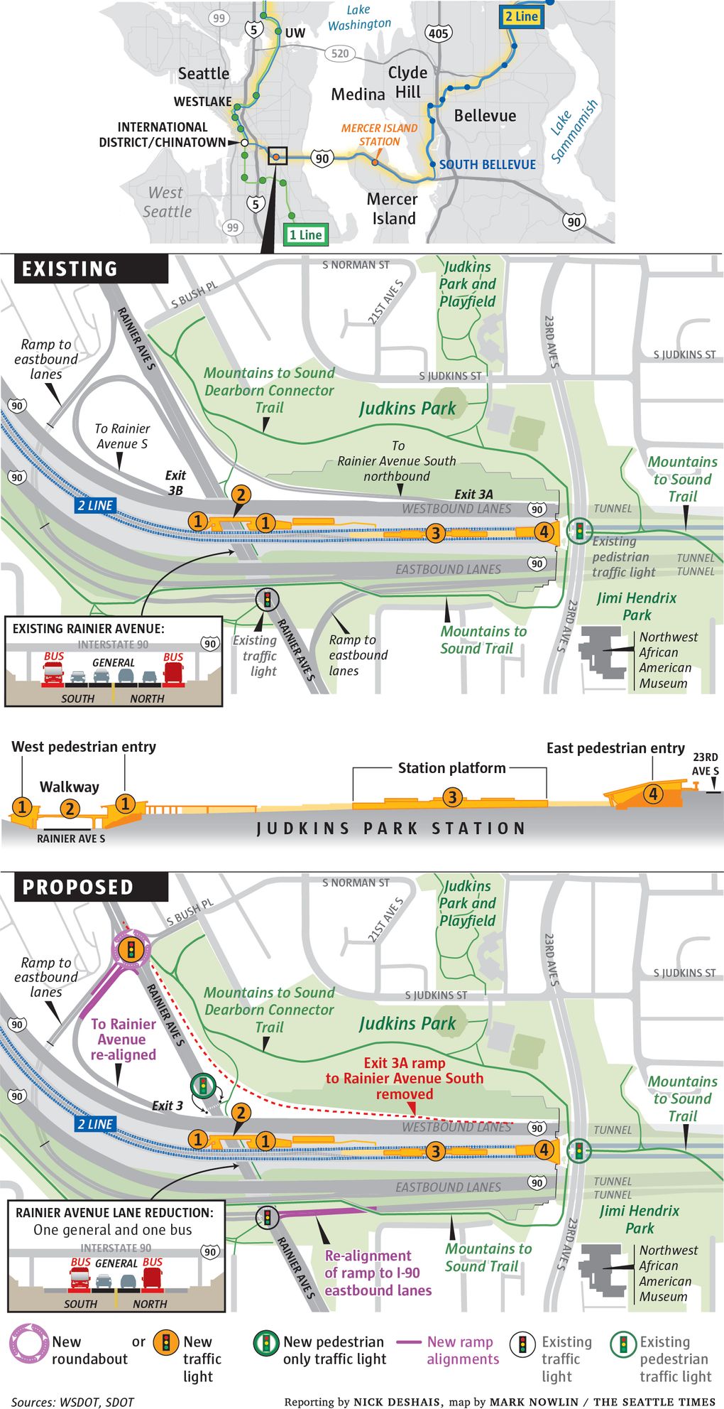
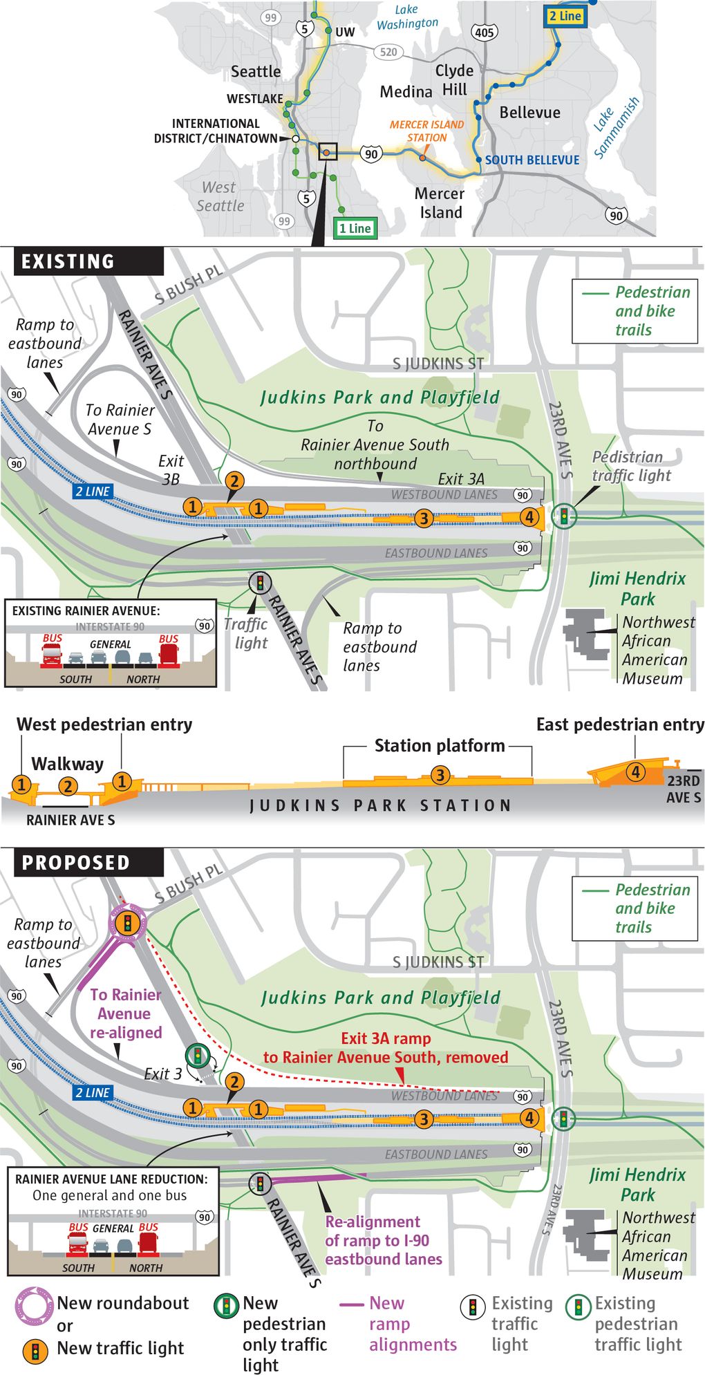
Still, the state and city transportation departments have already built raised crosswalks at the ramps and are installing flashing beacons, part of the work to ease connections to the station.
In 2016, Sound Transit estimated that 3,000 people would board the train at Judkins by 2030, 45% by foot or bike and 42% by bus.
And later this year, SDOT will repave Rainier between Jackson and Walden streets, a multiyear project that will include looking at WSDOT’s recommendations for the interchange and may add to the city’s growing portfolio of safer sidewalks and protected bike lanes, and to the overall push to slow vehicles down.
Zivarts, for her part, is trying to get to a bus stop. At yet another offramp — a long, curving way that’s a breeze to drive but terrifying on foot — cars zip by, seemingly unaware of anyone outside.
Hope and peril
When Salisbury, who leads the Black Legacy Homeowners project, looks at the neighborhood he grew up in and light rail’s arrival there, he sees hope and peril.
Salisbury knows hundreds of homeowners in the Central District who grew up there and have, so far, managed to keep their houses.
But with the increase in everything — home prices, property taxes, power bills — Salisbury worries that the station could just put more pressure on home prices and speed up gentrification.
“We are a big city that wants to get bigger. I understand that,” Salisbury said. “There is a cost to that, but we just need to be more thoughtful.”
Part of that thoughtfulness is keeping people in their homes, and part is remembering people like Sam Smith, Seattle’s first Black City Council member, and Jimi Hendrix, who grew up in the Central District before becoming a music icon.
The remembering, he’s not worried about. Salisbury is about keeping people in their homes, he said, and the government programs to help do so “are too little, too late for many people.”
“We have Jimi Hendrix outside and the Sam Smith lid park, but the people who Sam Smith sought to help are being erased. In the end, if we don’t do anything about displacement, we’ll be erased. It’ll just be a bunch of white people and murals and artworks,” Salisbury said. “We’re just going to turn into another land acknowledgment.”


